Monday, October 31, 2011

Hiking 26

I just saw this website called Hiking 26, and I had to blog about it. I have not done much research on this hiker named Ron Ulrich, but what I know is this: he will hike the Pacific Crest Trail (2600-miles) in 26 weeks, and will wear 26 wedding dresses for the duration of his hike. Yep, that's about one wedding dress per week.


I love this project! Here's why: his endeavor takes all the pretension out the current über hiker-than-thou thing going on in the long distance hiking community. We have so many people attempting speed records every year, using the trail as a platform to raise money for a cause, or showing off the latest ultralight contraptions or techniques. Ron Ulrich's Hiking 26 project is a fresh take on hiking the trail. It is a bit art, a bit challenge, and a slap in the face to everyone that takes their long distance adventure way too seriously. Is this project shameless self promotion? Yes it is. So what? So are all the other hikes that are documented on Trail Journals or Postholer. And people announcing their speed record attempts? It's huge self promotion.

I say, "Go Ron! Go! Have a great hike, and may all your wedding dresses whisk you gently to Canada!

Tuesday, October 25, 2011

Picture From Sky Camp

Back in July of 2010, my hard drive crashed on my computer, and I lost a lot of information.  What an idiot I was for never backing up information (lesson learned!).  I had some pictures on an external hard drive that survived, and they are my only photos remaining from the 2007-2010 era of my life.

I dug out a few pictures of a sunset and sunrise at Sky Camp at Point Reyes National Seashore in California.  I love the place, and I have hiked and backpacked there whenever the opportunity arises.  Anyway, I thought I'd share some pictures from a trip in 2007.   It was the first time I had ever camped at Sky Camp, and I was floored by the views.  Enjoy the pics!

Sunset and Waxing Moon with View Out to Pacific Ocean

Sunrise on Dead Tree with Pacific in Background

Sil-Tarp Sunrise at Sky Camp

Gear Review: La Sportiva Wildcat Mountain Running Shoe


La Sportiva Wildcat Shoe
I walked into the Nantahala Outdoor Center’s (NOC) Outfitter on March 16th just after closing time.  My 2007 Montrail Hardrocks were falling apart after a mere 70-miles of hiking on the Appalachian Trail, and I needed another pair of shoes to continue hiking north.  The salesman, a previous Appalachian thru-hiker named Alpine, told me that he’d take care of me.  Thank God.


My hiking partner, Found (PCT ‘06, CDT ‘10) had a pair of green La Sportiva Wildcat mountain running shoes, which he highly recommended, saying that they are now the new standard for long-distance backpacking.  I noticed that Alpine also had a yellow pair.  The gear shop sold a red-colored pair of Wildcats for $99, so I asked to try them on.

  
I tried on my usual size 9, which Alpine thought was a half size too small for my foot - I agreed.  Then I tried on a shoe a half size larger, which allowed for more room in the toe box. After ambling up and down a small, portable ramp, I felt that I found the right fit, and bought them.  I thanked Alpine for staying 15-minutes after closing time, and walked out with my new pair of shoes.


The Wildcats were super comfortable.  Unlike the rigid Hardrocks, which have a rock plate in the sole, the Wildcat’s Frixion soles had give to them, and felt gummy.  My feet liked this feeling.

Out on the trail, the soles gripped the AT’s tread of angled rocks and wood steps.  I felt confident with each step, and rarely did I ever slip on these surfaces, even when it was wet outside.  Muddy conditions were the “achilles heel” of this shoe, as I slipped and slid on ascents and descents.  However, I  think mud on the AT would cause most trail running shoes to do the same thing.


650-Miles of Wear on these Shoes!
I also found the Wildcats to be very breathable.  For the uppers, the shoe uses a lightweight mesh and thin inner liner, and in wet conditions, the shoe drained well, and dried out quickly.  I hiked a 350-mile stretch through the driest parts of the Pacific Crest Trail, and my feet never felt stifled by heat in the Wildcats.  They were perfect for the PCT!


I liked the lace harness on the Wildcats.  The shoes I purchased were roomy for my feet, but I felt that my feet were locked down in place due to the lacing.  Finally, I don’t know what La Sportiva did with the laces, but they never came undone on me on the trail.


Mesh Tearing from Sole
Alpine told me that I’d get about 450-miles out of the Wildcats, and he was right.  After hiking from Walker Pass to Highway 58 on the PCT in California, I noticed that the mesh was starting to tear apart from the sole on the right foot.  Then after hiking another 50-miles into the Antelope Valley, the mesh and inner lining on the Wildcats continued to tear away.   However, the soles had so much life to them that I continued to hike in them, and I added another 200-miles to Alpine’s 450-mile prediction.


I highly recommend La Sportiva’s Wildcats for long-distance backpacking, especially if one is going ultralight.  The soles are grippy and durable, the uppers are breathable, and the shoe is designed for the comfort of feet.  Even though they started to wear out after 450-miles, one can get extra miles out of them.  I believe in these shoes so much that I’ve already purchased another pair of Wildcats.  This time they are green!

* Here's a little article that was posted on September 18th, 2012 about the Wildcats being a hit among PCT thru-hikers. 

Saturday, October 22, 2011

Uncovering the Story of a Helicopter Rescue

Back on May 11th, the Riverside Mountain Rescue Unit airlifted a Pacific Crest Trail hiker near Snow Creek in southern California. The following video shows the rescue:

After watching the video, I could not figure what was wrong with the hiker. She was not unconscious, nor did she have broken leg. She looked fine! I did a little research, and I found a detailed report for the rescue, but the hiker's ailment was never listed. I was puzzled, and wondered if this rescue was actually necessary.

Then I found another video on YouTube that was related to this helicopter rescue. In fact, I recognized the hiker (Annie) telling the story using finger puppets, so I had to check it out:

Well, I guess that answers my question about why the hiker was rescued. I guess that's a legitimate reason, eh?

Props to the Riverside Mountain Rescue Unit for doing what they do. Keep up the good work!

Friday, September 16, 2011

I Will Complete the PCT in 2011!

38-miles to go. That’s all I have to hike to complete my 2003 Pacific Crest Trail hike and the Triple Crown. I embark on that 38-mile adventure today to finish these two milestones. Thank God. For eight years, these last 38-miles have been a haunting reminder that I am not done with the trail. Every year I attend Annual Day Zero Pacific Crest Trail Kickoff (ADZPCTKO), I see pictures of smiling hikers at Monument 78 at the Washington-Canadian border, and feel frustrated. I’ve not been there yet.

Conditions at Devil's Park in 2003
In 2003, my hike on the PCT was re-routed through the Devil’s Park area of the Wenatchee Wilderness, since the trail was closed from Rainy Pass to Hart’s pass. The only map I had of the area was the free, colorful North Cascades National Park map I got in Stehekin, WA, and it was useless in snowy conditions with limited visibility. I had also made a commitment to be in Seattle, and I had no time to kill a day waiting for the weather to clear, so I bailed on my thru-hike attempt.

I am resuming the hike where I left off: at the Devil’s Dome Loop trailhead. Yes, I am continuing on the re-route from 2003, as I will hike up the Devil’s Dome Loop to Devil’s Pass. From there, I will head east through Deception Pass, and reconnect with the PCT at Holman Pass, where I will make the run toward the border. After I get to the border, I will turn around, and hike south on the PCT all the way to Stehekin, where I will catch the ferry to Chelan. From there, I head to Wenatchee, WA to receive my Triple Crown award at the ALDHA-West Gathering.

The time has come for me to complete this hike, and I will complete it. I have a very detailed Trails Illustrated map (on loan from Chigger!) of the area, better equipment, wit and wisdom from hiking the CDT, and a bitchin’ attitude that I am going to get this thing done.

Weather Forecast for the Next 5-Days... Yikes
The weather is looking like crap again. As in 2003, mid-September is looking really “iffy.” Highs will be in the mid 50’s and lows in low 30’s with precipitation forecasted every day. I figure that if the weather gets really bad, then I will head toward Ross Lake, and complete the trail on the north end of that lake. However, that’s a really bad weather scenario, and I certainly hope to avoid that.

I will be checking in from the trail through my Twitter feed, and I hope to write a more detailed account when I get to Wenatchee.  Until then, Happy (and snow-free) Trails!

Saturday, July 9, 2011

Three Fuels for Your Alcohol Stove


A friend of mine is heading out to the Wind River Range for a backpacking trip, and he asked me what kind of fuel to get for his alcohol stove, and this was my response to him.
Typical Alcohol Stove

1. Heet - Gas line antifreeze, which is sold in the yellow bottle.  It must be the yellow bottle! If you get the red bottle, you will regret your alcohol stove for the rest of your trip. You can get the yellow bottle it at most automotive stores.  You can actually ship it to yourself in the mail, since it has a low flashpoint.  Yep, you can actually challenge your own postmaster on this point and win!

2. Denatured Alcohol - You can find this at most hardware stores. I know that stores in Southern California have pulled denatured alcohol (or this link) off the shelves, because the unburned vapor is not good for the atmosphere.  Usually denatured alcohol is used as a solvent or a thinner.

3. Everclear - They sell the real stuff in Wyoming (180 proof), and it burns the hottest and cleanest of all three.  My companions on the CDT used it for a stove fuel, and were very impressed with its performance.  Of course they also made CDTinis (CDT + Martinis) out of it, and served night caps for everyone at camp at night.  The problem with Everclear is that it is expensive, but it is ubiquitous, especially in a state like Wyoming.  You'd be the life of the party every night if you packed it out with you, cooked with it, and served your friends drinks at the end of the day.

One more thing about alcohol stoves is be careful when using them.  Please be sure to monitor them at all times, especially in dry areas.  I've heard too many stories on the Pacific Crest Trail, where an alcohol stove got out of hand, and caused a fire.  Enjoy your meals on the trail, or nightcaps if you choose the Everclear!

Monday, June 6, 2011

National Trails Day Work Party

I just spent the weekend with volunteers from the Mt. Hood Chapter of the Pacific Crest Trail Association, where we worked on a section of trail between Rock Creek and Sedum Ridge.  The work was done in conjunction with National Trails Day, promoted by the American Hiking Society.  Below is a video of the work we did, repairing tread, removing slough, and doing some brushing.  The work was strenuous, but a lot of fun.  Enjoy!

Saturday, May 21, 2011

California Desert Panorama

I took this shot after hiking south of Mission Creek in section C of the Pacific Crest Trail.  I love the desert areas of southern California, and was enamored by the great views of San Gorgonio Peak and Mt. San Jacinto.  Have a great weekend out there everyone, and take pictures!
Desert Panorama - Click Image for Larger View

Saturday, May 14, 2011

Video of Miller Fire on CDT in New Mexico

The Forest Service shot this video from a helicopter of the Miller Fire that is burning near the Gila Wilderness in New Mexico.  Apparently, the fire has been going on for a few weeks, and now over 300 personnel are fighting the fire.  A new fire, called the Sheep Fire also broke out north of Silver City, but appears to be small.  Northbound CDT hikers are being directed to go around the fire.


Thursday, May 12, 2011

Gear Review: La Sportiva Wildcat Mountain Running Shoe

La Sportiva Wildcat Shoe
I walked into the Nantahala Outdoor Center’s (NOC) Outfitter on March 16th just after closing time.  My 2007 Montrail Hardrocks were falling apart after a mere 70-miles of hiking on the Appalachian Trail, and I needed another pair of shoes to continue hiking north.  The salesman, a previous Appalachian thru-hiker named Alpine, told me that he’d take care of me.  Thank God.

My hiking partner, Found (PCT ‘06, CDT ‘10) had a pair of green La Sportiva Wildcat mountain running shoes, which he highly recommended, saying that they are now the new standard for long-distance backpacking.  I noticed that Alpine also had a yellow pair.  The gear shop sold a red-colored pair of Wildcats for $99, so I asked to try them on.
  
I tried on my usual size 9, which Alpine thought was a half size too small for my foot - I agreed.  Then I tried on a shoe a half size larger, which allowed for more room in the toe box. After ambling up and down a small, portable ramp, I found the right fit, and bought them.  I thanked Alpine for staying 15-minutes after closing time, and walked out with my new shoes.

The Wildcats were super comfortable.  Unlike the rigid Hardrocks, which have a rock plate in the sole, the Wildcat’s Frixion soles had give to them, and felt gummy.  My feet liked this feeling.

Out on the trail, the soles gripped the AT’s tread of angled rocks and wood steps.  I felt confident with each step, and rarely did I ever slip on these surfaces, even when it was wet outside.  Muddy conditions were the “achilles heel” of this shoe, as I slipped and slid on ascents and descents.  However, I  think mud on the AT would cause most trail running shoes to do the same thing.

650-Miles of Wear on these Shoes!
I also found the Wildcats to be very breathable.  For the uppers, the shoe uses a lightweight mesh and thin inner liner, and in wet conditions, the shoe drained well, and dried out quickly.  I hiked a 350-mile stretch through the driest parts of the Pacific Crest Trail, and my feet never felt stifled by heat in the Wildcats.  They were perfect for the PCT!

I liked the lace harness on the Wildcats.  The shoes I purchased were roomy for my feet, but I felt that my feet were locked down in place due to the lacing.  Finally, I don’t know what La Sportiva did with the laces, but they never came undone on me on the trail.

Mesh Tearing from Sole
Alpine told me that I’d get about 450-miles out of the Wildcats, and he was right.  After hiking from Walker Pass to Highway 58 on the PCT in California, I noticed that the mesh was tearing apart from the sole on the right foot.  Then after hiking another 50-miles into the Antelope Valley, the mesh and inner lining on the Wildcats continued to tear away.   However, the soles had so much life to them that I continued to hike in them anyway, and I added another 200-miles to Alpine’s 450-mile prediction.

I highly recommend La Sportiva’s Wildcats for long-distance backpacking, especially if one is going ultralight.  The soles are grippy and durable, the uppers are breathable, and the shoe is designed for the comfort of feet.  Even though they started to wear out after 450-miles, one can get extra miles out of them.  I believe in these shoes so much that I’ve already purchased another pair.  This time they are green!

Saturday, May 7, 2011

Fire on the PCT - Alcohol Stove Safety

I shot this video last Thanksgiving at the Mosley Manor up in Milwaukie, Oregon.  I focused on being careful with fire on the Pacific Crest Trail, especially in light of the fact that there have been three fires in the last five years started by hikers who mishandled their alcohol stoves.  I presented this video at the ADZPCTKO Video Shorts Festival.  So, this is for all you hikers out there who missed the Kickoff.  Enjoy!

Thursday, May 5, 2011

FIve Questions With Uncle Johnny

Back in March, I had the opportunity to sit down, and have a conversation with Uncle Johnny about his hostel right off the Appalachian Trail near Erwin, Tennessee.  I stayed at his hostel back in the early days when I used to attend the National Storytelling Festival, and I remember a time when he had plenty of room to pitch a tent on the lawn.  That lawn is now covered with cabins, as he has expanded his operations significantly.  I am happy for his prosperity.

I thought it would be great to get him on video, talking about the past, and his interaction with hikers.  Say what you want about Uncle Johnny and his strong personality, but he is an icon of the trail, and many hikers have been grateful for his services.  I know I have.

Well... here's the video, "Five Questions With Uncle Johnny."  Enjoy!

Wednesday, May 4, 2011

ADZPCTKO Presentations Over the Years

I love the Kickoff.  For seven years I have been involved with it as the Presentation Coordinator, and this recent event was my last in that position.  Yep, it's time to move on, and let someone else take over the reins.  I believe that one way for organizations to experience healthy growth is that they experience change, and thus my stepping down.

As the Presentation Coordinator, I have introduced many presenters to hikers in the Lake Morena pavilion, and I thought I'd list my favorite presentations from over the years.  So here it goes.

Winston Vickers
  1. Mountain Lions and Their Safety - Usually when I announced the presentation, everyone asked, "What about my safety?"  Wilderness veterinarian Winston Vickers has traveled to the Kickoff from UC-Davis three times to talk to hikers about mountain lions and the habitat that we hikers enter every time we explore the wilderness.  The reality is that humans continue to encroach on their habitat, and thus endanger these beautiful cats.  True, we also are risk entering their habitat, but attending Winston's presentation always helped me better understand mountain lions, and how to deal with them should I encounter one.  Finally, if there is one thing that was apparent from Winston's presentations, it is his passion.  He loves these animals, and he wants us hikers to have a better knowledge and appreciations for them.  I hope Winston comes back in the future.
  2. Paul Hacker and Greg Hummel
  3. Geology of the PCT - Greg "Strider" Hummel and Paul "Nohawk" Hacker both hiked the PCT in 1977, and are professional Geologists.  Their presentation on geology always fascinated me, so I attended everyone that they did just to see if I could scrape another nugget of information on the subject.  The Pacific Crest Trail runs across and along some of the world's most vibrant geological areas.  Consider that it crosses the San Andreas (and other faults!) several times, and it contours the Cascades' volcanos from northern California up to the Washington-Canadian border.  As Strider always says in his presentation, "Every rock is on a journey," and many of us hikers interact intimately with their journey as we traipse along the PCT.
  4. 1959 Thru-Ride
  5. Pioneering Women of the PCT - Barney "Scout" and Sandy "Frodo" Mann led this presentation in 2010, and it featured June Mulford, who along with her husband Don, thru-rode the PCT on horseback in 1959.  The presentation also had Teddy Boston, the first woman to thru-hike the PCT in 1976, and Carolyn Burkhart, who finished the same year as Teddy.  June Mulford's story was unearthed that year, so many of us there were eager to hear more about her ride on the trail.  Teddy, of course, is at the Kickoff every year, and is always entertaining.  Carolyn talked about her hike and how it helped her deal with personal struggles in her life.   It was a most memorable presentation. 
  6. Ken Murray
  7. Mountaineering Skills - On a heavy snow year, this is perhaps the most important presentation at the Kickoff.  Ken Murray has done this presentation every year that I have been involved with the Kickoff, and he balances the serious nature of hiking the Sierras along with making it an enjoyable experience.  Ken has also demonstrated how to ford river crossings, using an ice axe, and how to make a self arrest - all in the rugged conditions of the pavilion!  Ned Tibbits of Mountain Education has also helped Ken over the years, lending his rich mountaineering experience to the discussion.  
  8. Class of 2004 Photo Presentation - This is the class video that started a tradition that has endured to this day (Class of 2009 is the only one that has not been shown).  In 2005, Weathercarrot put together a photo presentation that set the bar high, and is now the standard by which all photo presentations are judged.  Panning in on dramatic images while mystical, ethereal music played in the background, he created the genre of video pleasure for eyes longing or eager to hike the Pacific Crest Trail. Thank you Weathercarrot!
Those are my favorite presentations at the Kickoff from over the years.  I am sure that the Kickoff will continue to flourish by bringing in knowledgable, talented, and entertaining speakers for years to come.  In the future, I look forward to enjoying those presentations as a participant, and not as a coordinator.

Saturday, April 23, 2011

Big Bear Lake for Easter Sunday

I pulled off the trail today to go to worship on Easter Sunday.  I have extra time on my hands, so I thought the opportunity could not be passed.

Spring continues to erupt throughout southern California, and a friend of mine reminded me of the significance of this time through the words of Martin Luther who said: "Our Lord has written the promise of resurrection, not in books alone, but in every leaf of spring time."  Of course the resurrection of Christ is central in the promise, but it is the 'ordinary' things in life that remind me of that great gift.  Yes, even the small, but colorful phlox ring out resurrection, even in a seemingly barren, desert landscape.

I am staying at the Big Bear Hostel here in Big Bear Lake, California.  I have the whole place to myself!  A hiker named Ari was here earlier today, but he left the trail to go to Los Angeles, and eventually to the Grand Canyon.  He said he could not handle the southern California desert sections, and was tired of the exposed sections of the trail.  I was puzzled to understand why he was leaving the trail, as I am really enjoying the desert environs.

I head out tomorrow after Sunday services.  I only have another 56-miles to hike by Wednesday morning, so I still have time to kill.  Therefore, I purchased a pair of hand loppers, and I will do some maintenance on the trail as I hike.  I thought I might as well take care of some of those stupid branches that cause us hikers to stumble or get caught in our eyelids.

Happy Easter everyone!

Wednesday, April 20, 2011

At the Saufley's in Agua Dulce

I have been staying at Donna Saufley's place (Hiker Heaven) in Agua Dulce for the last day, and I am enjoying my section hike on the PCT.  Section E was wonderful, and filled with poppies, water, and fair weather.  I am tackling Section C next, and I begin hiking at Cajon Pass tomorrow.  I am tackling Section C, because the re-route around Deep Creek is shorter than the huge 60-mile re-route that goes around the Station Fire burn area.  I leave tomorrow, and I will be on the trail for the next 132-miles.  Yipee!  Happy Trails.
Poppies are in Bloom in the Antelope Valley of California

Tuesday, April 12, 2011

Off the Appalachian Trail... Being FED on the Pacific Crest Trail

Found and Freefall at Elk Park (19E)
I finished my 400-mile stretch on the Appalachian Trail on April 3rd, so I could fly to California for an interview with the Pacific Crest Trail Association.  I am happy to be off the AT.

There are things that I really appreciate about the Appalachian Trail, but I am resolved that the trail is brutal on the knees, hips, ankles, and every joint below the torso... seriously.  The tread on the AT is rocks, roots, log steps, and mud.  I am not sure the trail has to be that way.  I think there must be a culture of machismo among the trail clubs that leave the trail in such a state of... blech!

I am now on the Pacific Crest Trail, and I am enjoying that better tread, grades, and weather.  The PCT is a hiker's trail.  Distant views are abundant along the trail, there's a sense of wilderness, and at this time of year, there's nobody out here.  I have this trail all to myself - it's a great feeling!

Abundant views are on the Pacific Crest Trail!
I just finished hiking Section F (Walker Pass to Hwy 58), and I am taking a day off in Tehachapi to rest.  I hobbled into town with an ingrown toenail, which I removed last night (don't ask!).  I also discovered a tick under my armpit while I was showering last night.  How long had that thing been there?  Due to a bad childhood memory, I absolutely hate ticks.  Anyway, that problem has been resolved too.

I am looking to also hike section E and D while I am out here.  Section E travels through the western arm of the Mojave Desert, which should be nice due to cooler temperatures.  Section D travels through the San Gabriels and up over Mt. Baden Powell, which should be adventurous.  A little bird told me that Section D might be closed due to a previous fire, so I may end up doing Section C instead.  I'll cross that bridge when I get there.

Hike on!

Thursday, March 31, 2011

Out of the Rain! Into Uncle Johnny's Hostel!

Found Hiking in Mist
As I write this post, it is raining cats and dogs outside. Right now, the southeast is just a big wet, muddy mess. The skies have been gray for 5 out of the last 6 days, and everything is just plain damp. This the the cold, wet AT that I signed up for!

When I started out on this hike, I was stunned by the nice, sun-filled skies. Temperatures were in the 60's and 70's, and I remember thinking to myself, hmmmmmm... it seems like the weather should be really crappy at this time of year. Well, it's now really, really crappy.

On top of Big Firescald Knob
Nonetheless, I had one really nice day between Hot Springs and Erwin, and I took advantage of it - I took a lot of pictures, and hiked a 20-mile day.  In spite of shifting rocks under foot, Big Firescald Knob had great views of the low country (and perhaps Knoxville) to the east and the Blue Ridge to the west.  It was an awesome day to be outside!

I have been hiking with Found (PCT 2006, CDT 2010) since Georgia, and I really enjoy his company.  What's interesting about our hiking relationship is that we are both interviewing for the same job with the Pacific Crest Trail Association.  How crazy is that?  One thing that I have discovered on these long distance trails is that it is a small world.  I have run into many hikers that I know (or hikers that I've heard of) on the trail over the years, so may be it's not so surprising.  While we may be competitors for the same job, we are companions out here on the trail.  I like that.
There was no view down to the Nolichucky River

I have only 50-miles to go before I am finished with this odyssey on the trail.  This next section of trail includes Big Hump and Little Hump, and Roan Mountain, which I remember being very scenic.  However, it looks like the weather will continue to rain over the next few days, so I am not guaranteed any sweeping views.  I will be getting off at Elk Park on Sunday, where I will meet up with my friend and 2009 CDT hiking companion, Patch.  I look forward to our meeting.

I am happy to be out on the trail, and I will check back in soon!

Sunday, March 27, 2011

Found's All You Can Eat Supper in Hiawassee, Goergia

Found and I stopped at Daniel's in Hiawssee, Georgia for supper.  It was an all you can eat supper, and we loaded up on the food.  Below is a little video of Found talking about his delight over the food.  Enjoy!

Saturday, March 26, 2011

Impressions: Two Weeks on the Appalachian Trail

Found taking a break at shelter
in North Georgia
Like the teeth on a gear, the Appalachian Trail has so many little ups and downs, and makes it one of the more physically challenging hikes of the the Triple Crown.  I had forgotten how taxing the grind of ascents and descents are on the body (yep, my knees are feeling it!), and I am now looking forward to rest here in Hot Springs, North Carolina, before hiking the last 110-miles of this journey.

This is the earliest I have ever set out on a trail (March 11th), and I am both bored and intrigued by the landscape of the southern Appalachians.  On the one hand, it is a grind to see a lot of the same scenery (dead leaves, rocks, denuded trees), while on the other I am watching spring foliage slowly explode, hearing more birds chirping, and seeing more wildlife.  It truly is a spectacle that only be seen by living in the wilderness on a day-to-day basis.  This spring spectacle seems more pronounced as I fluctuate from high to low elevations, where wildflowers are already in bloom.
Trillium in Bloom along AT

Every thru-hiker has humble beginnings, and I am reminded of that when I meet a lot of these newbie hikers.  I cannot believe how much stuff a lot of these hikers carry!  However, I am reminded that I also started out with a 50-pound pack on the AT in Maine in 2000.

I get a lot of questions from other hikers about gear.  I have been asked about my pack, and how I fit so little inside of it.  Some hikers have asked me when they should switch out their jackets, or when to start carrying bug spray.  I try to offer some advice, but I am hesitant to dole out too much.  I feel that people need to discover some of these things themselves.  I did tell one hiker not to buy the same backpack that I have, only because he would also have to switch out his sleeping bag and tent to make things fit.  He agreed that switching would be a bad idea at this time.

I have received a lot of trail magic out here.  One guy was cooking hot dogs at Woody Gap, and another was passing out chips and honey buns just north of Davenport gap.  I've also had hamburgers at Hogback Gap, sodas and chips at Unicoi Gap, and I am sure that I've missed out on many more trail magic opportunities.

Oak Tree at Georgia-North
Carolina Border
The trail magic thing here in the south has me feeling a little conflicted.  No doubt will I turn down a free hot dog, but I wonder if many of the northbound hikers get a little spoiled.  When I hiked southbound on the AT in 2000, I had a woman buy me lunch in Gorham, New Hampshire, which was completely unexpected.  That was the only trail magic I received until I hit Virginia!  Out here, I have received it 5-times in 2-weeks!  Honestly, I think hikers need to be a little more hardened to their experience.

Similarly, I am also amazed by the number of vendors, hotels, and hostel owners out here who are scratching for business from hikers.  It seems like every gap (Woody, Neels, Dick's Creek, Winding Stair) in Georgia and North Carolina has free hiker shuttles to hotels, hostels, or an outfitter waiting to change out one's heavy pack for a lighter one.  Again, when I stated out my hike up in Maine, I had none of those options!  I lament the commercialization.  However, I can see the flip side to the coin that it's good for one to have options to switch out gear to encourage a lighter, more enjoyable hike.

A Snowy, Foggy Morning on the AT
All in all, I am charmed by this experience, and I have met some wonderful people out here.  The people out here love to be outside, and enjoying the wilderness.  Hiking the trail is an enriching experience for anyone, which teaches responsibility, simplicity, and a deep care for creation.  I love this lifestyle, and the people who embrace it.  I love these AT hikers!

Tuesday, March 15, 2011

Rest in Hiawassee, GA

I am in Hiawassee, Georgia for a short break.  I stayed at the Blueberry Patch Hostel, which is 7.4-miles outside of town, and I definitely recommend staying there.  I get back on the trail later this afternoon, and then I will huff it to Fontana Dam, where I will be arriving on the 20th of this month.  I am really enjoying my AT experience again, and after eleven years off this trail, I have to say that there's not much of it I recognize!  So, in some ways, I feel like I never hiked this trail before.  More to come later.

Thursday, March 10, 2011

Looks Like Great Weather Ahead

The rains have moved through Georgia, bringing with it cold temperatures and high winds. However, the weather report looks great for the next three days.

I am excited to get back on the Appalachian Trail. I am poising myself to hike 20-mile days up to Fontana Dam to meet up with Squatch there. Although this will be a short journey (3 1/2 weeks), it should be epic! I
The Hiker Hostel in the North Georgia Mountains

hope to check in again in four days with a full report with my impressions.

I am staying at a lovely hostel called the Hiker Hostel. This place is seriously the Taj Majal of hostels. It is a beautiful log cabin with three levels for hosting hikers. The owners, Josh and Leigh Saint, have decorated this place with all kinds of pictures from their previous hikes. This is the place to stay in North Georgia.

Monday, March 7, 2011

Video: The Green Tunnel

This video about the Appalachian Trail's green tunnel is making the rounds on the web, and I agree that it is pretty sweet to watch. Enjoy the AT in 5 minutes!


Green Tunnel from Kevin Gallagher on Vimeo.

Thursday, March 3, 2011

Appalachian Trail Hike: 3-Weeks

I learned the other day that I will only be on the Appalachian Trail for three weeks.  I figure that's enough time to scramble up to Erwin, TN (or perhaps a little further) before I have to catch a flight out of Knoxville.  This is certainly not bad news, because I am leaving the trail to interview for a job with a well-known trail organization.  Yep, I have the opportunity to land a dream job, so I have to go for it.

That said, after the interview, I plan to hop on the Pacific Crest Trail near Mojave, and hike south for a few weeks.  I am pretty excited about that.  Now, if only I can figure out a way to hike on the Continental Divide Trail for a few weeks, then the circle will be complete.  Who knows? It might happen.

I leave for Georgia in a week, and I getting excited.  I have a lot to do in the next week to prepare for the AT, and living the drifter lifestyle for the next two months.  Look for more updates here as March 11th approaches.

Sunday, February 20, 2011

Wednesday, February 16, 2011

Getting to the Appalachian Trail's Southern Terminus

Freefall at Springer Mountain, GA
I am making plans for the Appalachian Trail... finally. One thing is certain: I will be meeting up with Squatch up at Fontana Dam, NC around March 20th. However, getting to the Appalachian Trail's southern terminus (Springer Mountain) is still up in the air.

I did a Google search "shuttle to Springer Mountain, Appalachian Trail," and I turned up a wealth of information. Whiteblaze.net had some great suggestions.

Hiker Hostel, which is operated by Josh and Leigh Saint (770) 312-7342 looks to be the top choice. They offer a Thruhiker Special, which includes a pickup at the North Springs MARTA station, one night's stay, breakfast, 8 oz. of denatured alcohol, and a shuttle to Amicalola Falls State park. As of 2010, they charged $75 for the service, which seems very reasonable. I first read about them in an A.T. Journey's Magazine, and have been eager to check out their place. I also know that Josh and Leigh hiked the AT in 2000, so I guess I am biased to choose them. I signed up for a reservation online, and I look forward to hearing back from them. Hopefully they can swing the ride.

There's also a guy named Survivor Dave, (678) 469-0978 who also provides a shuttle from the North Springs MARTA station. The good news is that it looks like he keeps things simple: he takes one to the trailhead. The bad news is that he does not post a price. That actually deters me from choosing him. Second, I think it would be easier if there was a way to sign up for a reservation online instead of having to make a call. Not that I am averse to the phone. It's actually a west coast-east coast thing. As I research this at 8pm on the west coast, I am not apt to make the call at 11pm EST, and I am not going to remember to do it the following day. Nonetheless, he seems to run a good barebones service.

The Appalachian Trail Conservancy also provides a shuttle list, which includes others like Appalachian Adam and North Georgia Outfitters. Based on what I've seen online, I imagine anyone operating on their own schedule or with a myriad of needs can score a ride to Springer Mountain... I think I did (keeping fingers crossed)!

Tuesday, February 15, 2011

Fuel Canisters and the PCT

Do you carry an Optimus or MSR Whisperlite stove that uses Isobutane fuel canisters? Are you hiking the PCT, and looking for places along the way to purchase fuel? Check out Erik the Black's webpage on places to purchase fuel along the way. It's a pretty good resource for planning a hike on the PCT. Perhaps one could cross reference Erik's information against Yogi's PCT Guide.

Click the Pic to Go To Erik the Black's Site

Are you planning on mailing fuel to yourself?  Did you know that you can send most stove fuels through the mail?  Check out Ken and Marcia's website Gottawalk, which has a page dedicated to stove fuel and postal regulations.

Click the Pic to go to Ken and Marcia's Website
Finally, have you not purchased a stove or made one yet?  Check out Sectionhiker.com for some recommendations on buying a stove that uses isobutane canisters.  If you want to build your own alcohol stove, click this link to build Scott's Pepsi-G stove.  I build one of these stoves in 2003, and it still works great to tis day!

Sunday, February 13, 2011

Another Beautiful Day Hiking in the Bay Area

This is a blog about long-distance backpacking and thru-hiking.  Recently, I have been posting about frolicking in the outdoors here in the Bay Area, and I will continue to do so. After all, what do long-distance hikers do in the offseason?  True, some will head south to hike the Florida Trail or perhaps portions of the Arizona Trail, but not all of us the year-round luxury or resources to do that.  So, we hike on the weekends, and in our own parks.

Yesterday, I had the opportunity to head up to Point Reyes National Seashore... again!  Yep, I think I've been there maybe 20-times for a day hike or a backpacking trip, and I absolutely love the place.

I never get bored with Point Reyes.  Every time I go there, I feel like I am walking into an area rich and diverse in history, plant and animal-life, geology, and geography.  For starter's, this place shifted 21-feet to the northwest in 45-seconds during the great San Francisco earthquake of 1906 (take the earthquake trail, located on the San Andreas fault to learn more!).  Geologists say that the rocks in Point Reyes are the same as the rocks in the Tehachapi Mountains 310-miles to the south

Point Reyes also hosts elephant seals, whales, dolphins, tule elk, bobcats, coyotes, red-tail hawks, porcupines, reptiles, and the list goes on.  I cannot think of another place that I have hiked that is so rich and abundant with animal-life.

Finally, plant-life is off the charts.  According the National Park Service website:
"The broad range of plant communities supports over 900 species of vascular plants - pretty amazing! This number represents about 15% of the California flora. Sixty-one species found in Marin County are known only from Point Reyes."
One can stumble upon redwoods, Douglas fir, horsetail, sword fern, seaweed, algae, poppies, buttercups, and lilies.

Below are some pictures form my recent hike along with my friend Lynn.  My legs felt great yesterday, and I am really getting my sights set on my hike on the Appalachian Trail coming up in March.  Yep, I am going to get on the AT for a few weeks and walk with spring!  So, I am looking at these Bay Area hikes as a good primer for my upcoming section hike.  I will share more about that later on.

Up on the Sky Trail in Point Reyes

Approaching the Sky and Woodward
Valley Trails

The Most Awesome Tree Ever!
Located On The Sky Trail


Seagull Perched on Arch Rock


View North From Arch Rock

Lynn Runs on Beach Below Arch Rock

Sunday, February 6, 2011

Marin County Hiking At Its Finest!

Map of Mt. Tamalpais State Park and Muir Wood National Monument
Describe a classic hike in Marin County, and one might get several responses: "Take the Miwok Trail in the Marin Headlands" or "Climb the summit of Mt. Tam for panoramic views!"  I offer a classic route emblematic of the Marin County hiking experience that captures its diversity, beauty, and challenge.

With my friend Lynn, I started out on the Dipsea trailhead at Stinson Beach (a part of the Golden Gate National Recreation Area), taking a small side road, and crossing Highway 1.  The trail climbed gradually through coastal chaparral, and briefly entered a forest glade, offering cool shade on this warm, sunny day in February.  The trail topped out at an overlook, offering splendid views of Stinson Beach, Bolinas Bay and Bolinas Lagoon.
Freefall with Stinson Beach in the Background

We re-entered forest, and descended shortly to a bridge, which is the intersection of the Dipsea and Steep Ravine trails.  Lynn and I crossed over Webb Creek continuing east on the Dipsea trail, and then climbed a long series of stairs up steep terrain.  As we ascended occasional trail runners passed by us - this trail is famous for an annual footrace!  We continued huffing and sweating up the trail under a canopy of madrone and bay trees, which later transitioned into a young redwood forest.  The scene was serene!

The Dipsea trail left the shade and continued through sunny open space, offering beautiful sweeping views of the Marin Headlands and San Francisco to the south, Oakland and Mt. Diablo to the east, and the Farallon Islands to the West.  Here, Lynn and I took a break to eat a sandwich, bask in the sun, and admire the views.

Lynn Poses Near a "Family Circle" of Redwoods.
We then descended steadily east on the Dipsea Trial through a mixed forest of Douglas fir, tanbark oak, and madrone trees.  We came to an intersection of the trail which alerted us of a bridge closure over Redwood Creek at Muir Woods National Monument.  Instead of taking the official detour, we chose to be adventurous, and continued on the steep drop down the Dipsea.  We easily crossed shallow Redwood Creek near the dismantled bridge, and entered Muir Woods.

Muir Woods influenced me to move out to California... seriously.  When I first saw the old-growth redwoods here in 2002, I was amazed and awed by their size - I had never seen anything like them before.  I was also blown away by the fact that they are located so close to San Francisco.  I continue to be enamored by the redwoods.  Muir Woods is an outdoor cathedral filled with 250-foot tall redwoods, sword fern, sorrels, and banana slugs, which should be visited by everyone.  That said, on this Saturday, it seemed like everyone was visiting Muir Woods!  Through the first mile of our hike, it was hard to escape the crowds wanting to visit this place, but after crossing the fourth bridge, near the Alice Eastwood Trail, our journey was less congested and much quieter.

Our journey continued up the Bootjack Trail, which follows narrow ravine of Redwood Creek.  Several times I was drawn to photograph quaint, beautiful falls and mushrooms along the trail.  We climbed steeply out of the dark canopy of redwoods, and re-entered a forest dominated by mixture of young redwoods tanbark oak, and bay trees.  Along the way, we passed a few hearty tourists, who had hiked more than 2-miles form the Muir Woods parking area - props to them for sucking the marrow from the bone of life!

Falls on Redwood Creek
Lynn and I left the Bootjack Trail, and reached the Pantoll Ranger Station after a short .4-mile hike on the Alpine Trail.  At the busy campground, we sat down for a rest, which included a second lunch, and refilling the water bottles.  I admired the number of outside cycling, hiking, or just frolicking in the outdoors - this is how life should be!

We continued our journey on the Steep Ravine Trail, which follows the aforementioned Webb Creek back to the Dipsea Trail.  True to its name, the trail is indeed steep in many areas.  At one point along the way, Lynn and I had to climb down a 10-foot ladder!  Nonetheless, it was a beautiful descent through a deeply carved ravine, lined with thickets of sword fern and the occasional forget-me-not flowers.  At one point along the way, I had to stop and admire what appeared to be a rare trillium.  We also ran into several hikers going the opposite way, scrambling back to the Pantoll Ranger Station before the sun set.

We reached the Dipsea Trail again, closing our scenic loop hike.  We ascended familiar trail, but were treated to a different scene, as the sun was starting to set.  The coastal mountains of California now had deeper colors and more depth in these golden hours - my camera was very happy to be out of the harsh mid-day light.

Lynn and I scrambled down to Stinson Beach just in time to catch a picturesque California sunset.  Kids were still playing on the beach, and couples were basking in the final rays of sunlight on what had to be one of the most beautiful days in February ever!  I thought about the wonderful diversity I had just experienced: beach, forests, ridges with panoramic views,  redwoods, and deep ravines.  Can I experience Marin County more fully?
Sunset at Stinson Beach

Monday, January 31, 2011

Urban Backpacking Trip to Hawk Camp

It's nice to have a car to go places for hiking and backpacking.  Ever since I got rid of my truck four years ago, I am not traveling as much to backpack those special destinations.  I now rely on friends to drive, public transportation, and my own two feet (yes, my own two feet!) to get around.
Sunset Picture of the Marin Headlands from Bobcat Trail

One of the joys I have discovered about being in San Francisco is that one can simply walk out the front door, and go on an overnight backpacking trip without the car.  Recently, I took a trip to Hawk Camp, which is located in the Golden Gate National Recreation Area.  The beauty of walking from the front door to the campsite is that the city itself becomes the hiking landscape.  Who says that mountains, trees, and rivers have to be the dominant features?  Hiking through the city is seeing the culture at work, the citizenry at play, and becoming more familiar with the urban geography and its unique features.

I hope the video I made captures some of the nuances of urban distance hiking, and the reality that our wild spaces are closer than we think.  Bear in mind here that those coyote yelps and owl hoots are just a few miles from San Francisco!  This is cool.

Saturday, January 29, 2011

Pictures From Sky Camp

Back in July of 2010, my hard drive crashed on my computer, and I lost a lot of information.  What an idiot I was for never backing up information (lesson learned!).  I had some pictures on an external hard drive that survived, and they are my only photos remaining from the 2007-2010 era of my life.

I dug out a few pictures of a sunset and sunrise at Sky Camp at Point Reyes National Seashore in California.  I love the place, and I have hiked and backpacked there whenever the opportunity arises.  Anyway, I thought I'd share some pictures from a trip in 2007.   It was the first time I had ever camped at Sky Camp, and I was floored by the views.  Enjoy the pics!

Sunset and Waxing Moon with View Out to Pacific Ocean

Sunrise on Dead Tree with Pacific in Background

Sil-Tarp Sunrise at Sky Camp

Tuesday, January 25, 2011

Question and Answer with Sage Clegg

     A few months ago, I read about Sage Clegg through a Google Alert. Sage completed her hike on the Continental Divide Trail on August 31st, and two weeks later, she set out to hike the Appalachian Trail, finishing on Christmas Eve. For those of you who don’t know, Sage is the first woman to complete the Triple Crown in less than 18-months. Her hiking credentials are off the charts, as her first thru-hike was a rare southbound trek on Pacific Crest Trail - that’s rad! She also completed here CDT-AT hike in just over seven months. Sage is a machine.

      The following is a virtual question and answer session with Sage. Thanks to Sage for allowing all of us to learn what makes her tick, her highs and lows, and how she got that name ‘Sage.’ Enjoy!


Where do you live, and what do you do for a living?

     Northern California is my home. I grew up in a small town in Mendocino county, went to college in Santa Cruz, and am currently attempting to move to Tahoe to learn to ski.  I work as an instructor for Outward Bound (but not much in the past 2-years) and as a wildlife biologist in the Mojave desert.


Tell me about your gear. What was you favorite?
  
      This year I used an Osprey Exos 34. To date, it is the most comfortable pack I have used because of the ventilation system, but I went through 3 packs in the 4700-mile season - Osprey is working on the problem. Last year I used their Tallon 33, and I loved it, except that it wore out 5 shirts, not to mention some of the skin on my back - that is not an issue with the exos - I used the same shirt for 4600-miles!
     I used my MontBell Super Stretch 30 degree bag for the entirety of my Triple Crown. I love this sleeping bag amp; can't believe it worked so well even in the uber cold of the AT. I also used a silk liner and a MontBell UL sleeping bag cover. I carried 2-puffy jackets and used them as blankets inside the bag each night. In Colorado I was worried about being cold and carried 3-puffies, but that was a bit overkill.
     My tarp is a little 8oz thing I bought off a friend. I have no idea who made it, but it was perfect for me.
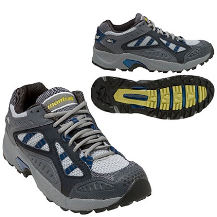
      I am sponsored by OBOZ shoes based in Montana. I used a pair of their shoes for 900 miles on the PCT, and this summer tried a variety of their shoes, all of which are awesome. I started out with the Hardscrabble, moved to the Contour, then the Sawtooth, and found the Dash before I went to the AT. When the snow storms hit and my toes started to freeze in the runners I had a pair of the Galatin's shipped out and I LOVE them. I always think I should be stoked on runners, but then when I get into a light hiker my feet are usually happier.
     I use Superfeet insoles, and for much of the CDT I carried Crocs to give my feet a break on road walks. A friend told me he made some Croc insoles with a belt sander, so I convinced a guy at a ski shop to help me make a pair. They were awesome with the Sawtooths, but wouldn't fit in the Contours, so they made their way to the bounce bucket.
      I am attached to everything in my pack, but my favorite thing is my mp3 player. I really enjoyed the company of music. I had some rules about when and how I listened to it, but I would have music in my ear (I have A headphone rather than two so I can hear my surroundings) about 8-hours a day.

How did you get the trail name “Sage”? That is a trail name, eh?
  
      Nope. I was born and my parents decided to call me Sage. Little did they know they dubbed me with a trail name from day one. I am pretty sure I would have acquired a trail name if I hiked a trail around other people, but since I am always going the wrong way nothing has ever had time to stick.


How did you first get interested in thru-hiking? Any inspirations or motivating factors?

     When I was 14, I went on an Outward Bound course. On day 3 I decided to become an instructor some day, and that is when the PCT entered my consciousness.  I always assumed the PCT was an unattainable goal. Then, in the fall of 2008 I found myself ending my 6-year instructing career with Outward Bound, because they were shutting down my bases (Montana and Texas). I was devastated, but I decided to double time on my other job, Tortoise biology in the Mojave.
     I arrived in the desert for a contract and two days into the season the contract got canceled. I was down two jobs in the span of two months. I called my friend Pepper and he said whenever he is down on his luck and feeling poor he goes for a hike. I asked where I could hike in November and he mentioned the Grand Enchantment Trail (GET). Two weeks later on November 14, 2008 I set out from Albuquerque on my first thru-hike on a deserted and freezing GET. My 29th birthday was on the 18th, and I sat down eating a birthday brownie a friend had given me, and I decided I would hike 3000-miles before I turned 30. 27-days later I reached the Arizona-New Mexico border completely in love with thru-hiking, 450-miles closer to my goal of 3000. 


According to reports, you are the first woman to thru-hike the Appalachian, Pacific Crest, and Continental Divide trails in an 18-month period. Was that your intention when you took your first steps on the PCT? If not, what led you to go for it? How does it make you feel to be the first woman to hike all three trails in 18-months?

     When I started my southbound PCT hike in 2009, I wasn't sure if I could even get through Washington. Then I made it to Oregon, and took a 20-day break to go work a course in the Sierras. When I returned, I wasn't sure if I would make it to California. Then California hit, and I was running to get through the Sierras before winter shut me out. Even when I reached Campo I still didn't believe I could do it, but I had.
     I went out to try and finish the GET a few days after I finished the PCT. Two days into that hike it was my 30th birthday. I woke up early, shooting for a 30 on my 30th, but when I stood up from lunch I could hardly walk. I had strained both my knees on the wonderfully steep and uneven terrain of the GET - I guess I had gotten soft on the PCT trail tread! I walked the 80-miles to Safford Arizona, going backwards down hills and trying to convince myself to go home and heal up, but letting go of a dream has never been my strong suit. I begrudgingly left the GET for home with 218-miles left to go for a winter of doctor visits and physical therapy routines.
     When I started the CDT in May, I was uncertain if I could even make it through New Mexico, much less to Canada. The miles started passing, and I got into the groove.
     In Pie Town, New Mexico I was reading the register and saw Li Brannfors entry from 2007. He had signed with this awesome looking CDT/AT logo and from that moment on I couldn't shake the idea of hiking them both in a season. I tried to talk myself out of it for a lot of reasons. Would I be able to handle 8 months of hiking? Would I get out to the AT and have a GET knee injury again? Would it even be fun anymore? Would I ruin my passion for hiking? But the thought of hiking the AT southbound in the fall meant fall colors, no bugs, fewer crowds... and I just wanted to try it. The idea was something logic and reason could not sway. So I told myself that if I finished the CDT before September 1st I should go out to Maine. Travel from Montana to Baxter State Park fell into place so easily, and then suddenly I was hiking on the AT!
      I didn't realize I would be completing my Triple Crown in 18 months until I was wandering through Vermont one afternoon. Once I realized that it definitely had an effect on me. Suddenly I had a time goal and my ego was attached to the hike for the first time. I couldn't believe that I might be the first woman to have done this. There are so many other amazing female hikers and athletes out there, and I am sure my “record” will be surpassed as soon as other women realize that it can and should be done. Part of me wants to try for a calender year, but right now I don't really want to cover all that ground again.
     I hope my 18-month triple crown will inspire other women to get out and hike. Solo or not, thru or section, heavy or light, it doesn't matter. I think the world will be a better place if more people know themselves and true wildness better. Getting out onto a trail is one of the simplest paths to self discovery. John Muir hit it on the head: Going out is really going in. I hope I have been able to open the door to the interior for a few people other than myself. Hiking feels so selfish sometimes, but I want my adventures to be shared, so I am not the only one who gets the glow. 


What was it like for you to go from thru-hiking the CDT, a largely non-blazed, navigational challenge, to a white blaze highway like the Appalachian Trail?

     My first lesson was that the AT was no cakewalk. I couldn't believe that THOUSANDS of people had scrambled over those rocks and roots! The second lesson was that I realized I hike to be free. The white blazes were always telling me where to go. I felt stifled on the AT and had to work really hard to adjust my perspective so I could enjoy my time out there. For a more thorough explanation check out my last postholer entry.

Were there any challenges to going straight from the CDT to the AT? How were you feeling physically, mentally, and emotionally at the midway point and at Springer Mountain on the Appalachian Trail?

     Katadhin kicked my ass. I took a zero on day two to recover and tried not to freak out too much. I was really worried I would have a GET repeat. By the end of the 100-mile wilderness my knees still hurt, but they were walkable, and I knew that as long as I didn't go too hard I could stay on the trail. I almost quit at the end of Maine because I was hating the trail and I had a good work offer back in California. I couldn't convince myself to leave though. I kept thinking that if I came off I would have to hike ME again and I don't ever want to deal with those bog bridges and SEGAL (Sensless Elevation Gain And Loss) trail again.
      At Harper's Ferry I got food poisoning, but the weather was really good and my spirits were high despite having to dig holes every couple of hours.
      December was filled with snow and ice storms and the only reason I didn't come off was because I was so close to the end. The last 24-days of my AT hike were some of the hardest days of my life. My motivation had tanked and things that had once been fun were miserable, it was too cold to crave ice cream, I was worried about finishing on time, getting out of my sleeping bag was almost impossible (one very cold morning it took me 4-hours!). If I had been fresh four blizzards in a row would have still been hard, but it is amazing how much attitude controls enjoyment. I had run out of tolerance and patience for challenge and it took everything I had to plow through the snow.

Of three trails, what was your favorite trail? Why? If you could hike one over again, which one would you do first?

     The CDT is so wild. I loved it.  The PCT is stunning and allowed me to fly along at a pace that doesn't seem possible. I don't think I will re-hike either in their entirety again, but they will both be incorporated into routes I am making.


Describe for me your favorite moments on the AT, PCT, and CDT? What were your most miserable moments?

     AT - High: Cutting down a christmas tree with the family at Standing Bear Farm during a bilzzard induced zero day.  Low: Bailing to a low route in the Smokies after deciding I was too much of a wimp to hike over drifts of snow alone for 6 days.

     CDT - High: So many, it's hard to choose. Seeing a pack of 5-wolves on a hill top at sunset near Lima. Seeing and hearing my first Willow Fly Catcher in the headwaters of the Missouri River.  Low: Sleeping by a broken bridge near twin lakes, CO after a 15-hour day in which I hadn't even gone 30-miles (I was pissed) and having nightmares all night about the bridge breaking. In the morning I crept over the broken bridge, went into town, and re-united with my friend Ahab, from whom I had been separated the day before. He informed me that there was another un-broken bridge about 3-minutes upstream from where I had crossed. I couldn't believe I had been so unaware!

     PCT - High... Yep. That is how I felt on the PCT. My night at Drakesbad Guest Ranch was AWESOME! They fed me the most amazing steak I have ever eaten along with endless cups of hot chocolate, and then I got to have the whole hot spring pool to myself and sleeped on a comfy couch!  Low: Getting snowed out of the sierras the first time. The storm hit just after I crossed Donahue pass and I came out at Devil's Postpile. I was pretty sure I would have to miss the 250-miles I had been most looking forward to, and that was pretty devastating. A friend of mine helped me figure out a way to get back into the mountains with only missing about 10 miles of trail. A weather window opened, and I made it over Forester Pass before I got snowed out for a second time. Creativity, flexibility, and the help of friends let me stay on the trail and have a successful hike, but I have never felt so sad and disappointed as I did on October 4, 2009 when I hitched into Bishop. 


What are your plans for the future? Another hike?

     This off season I hope to learn how to communicate more effectively by finding my inner computer geek side. I want to be able to get the word out a bit more about how cool hiking is and advertise the Emily Sandall Foundation. As I hike, I am trying to raise funds for the Emily Sandall Foundation, a non-profit that creates opportunity for true childhoods all over the world. That means they give scholarships for backpacking trips here in the states and provide mini-grants and other financial support to people doing grassroots projects that work against child labor. Check out emilysandall.org for more info. This foundation was created in honor of my good friend Emu who passed away in a hiking accident on Half Dome 4-years ago. She would have loved thru-hiking and I think about her often when I am on the trail, so my footsteps are for her. Figuring out how to ask for money and to communicate to a larger audience is something I struggle with - I don't want to feel like I am bragging or begging. I do believe whole-heartedly in the organization I hike for, and I also know that me telling other people about my adventures will inspire them to get out and challenge themselves too. I just have to buck up and learn to sit in front of a computer.
     This summer I am hoping to put together a route that connects the Pacific Ocean in Mendocino to Death Valley. I'm calling it the Japhy Ryder Route and hope to start it this June.


If you could give one piece of advice to anyone wanting to do a long distance hike, what would you tell them?

     You have to go to know. Get yourself out the door! (It is worth quitting your job for, the universe will provide, and money isn't everything. Just try it- life isn't a chess game, you can't plan it because plans fall through-- JUST LET YOURSELF GO HIKING!!).

How are you readjusting to life after the trail?

     I just went to an acupuncturist and she said the symptoms I was describing are what people usually say when they go into the backcountry. I guess for me it is reversed because I am more comfortable out there than in cities. 
My readjustment could be going worse, but it is pretty intense at the moment. My truck died while I was away, and since it was at my house I have had to scramble. I do have an amazing community here in central California to help me out. I have a great place to stay while I recollect the pieces, sort through 8-months of mail, buy a new truck, get my teeth filled (I ate too many jolly ranchers on the trail I guess..), and search for work. All my dreams of renting a place in Tahoe and skiing all winter have been put on hold, but surfing and spending way more money than I have isn't that bad either. I will start work sometime in March, so for now I have to provide myself structure. I think this is the hardest part. I have too much freedom at the moment, and my drive to do hard things is non-existent. I am a bit of a couch potato these days, and the efficiency standards I have held myself to for the past 8-months have no place in my current lifestyle.
     Last winter I got pretty depressed and I hope to avoid that this year. I am trying to get into running shape and do yoga, but I am so used to having my exercise be a part of my daily life that carving out time for it is a challenge. I guess it is a challenge I will just have to rise to if I don't want to ferment in self pity this winter.
     Another thing to help me avoid the post trail blues is the planning of the Japhy Ryder Route. Even though I don't need to use maps every day I still get to look at them, and it is quite therapeutic.