Day 3 Camp North of Vincent Gap to Cajon Pass - 33-miles
 |
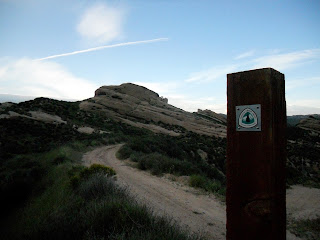
| View of Baden-Powell from PCT Marker |
From Vincent Gap, the trail ascended 800-feet to Blue Ridge, where the trail leveled out, providing occasional sweeping views east toward the Mojave Desert. Patches of snow occasionally covered the trail, but posed little difficulty for hiking.
At Grassy Hollow Visitor's Center, I refilled my water bottles, and took a moment to capture a picture of me standing next to a PCT sign with posted mileages to Mexico and Canada. I remember this sign from my 2003 hike, and it seems like I see this picture every year in photo presentations at the Kickoff.
Climbing out of Grassy Hollow, my sights were set to the west, where I could see Mt. Baldy, and beyond it, a band of rain moving toward me. Great... rain... Before I left on this trip, I heard that a storm was moving in, but I did not know that it was moving in this early! Rain began to spit on me, and then turned into a steady shower. I donned my rain jacket. I kept hiking to the next intersection with Highway 2, where I took cover under an informational kiosk. Was this the monumental storm I heard about moving in early? Should I hitch to Wrightwood, and get off the trail early? If I do that, when am I ever going to get back to this point to hike from here to Cajon Pass? I donned my rain jacket, and decided to push on.
 |
| "Famous Sign" |
After crossing Highway 2, I ascended toward Mountain High West ski resort. The steady rain that had fallen earlier stopped completely, and skies started to clear up. I pulled the rain jacket off during a surprisingly 'brutal' climb (by PCT standards) up what appeared to be an old jeep road, which may be a remnant of development from the ski resort.
I came to a large, open, fenced-in, plastic-lined, man made water tank. By wilderness standards, this is thing was out of place, but by skiing standards, it is essential for making snow at the resort. Regardless, it is ugly.
I stopped for a short break, and absorbed the scenery to the west. Again, I looked back at Baden-Powell, and it's daunting, dramatic, west-facing slope. The weather was now downright sunny and warm. What a perfect moment!
 |
| A view of Mount Baldy from Blue Ridge |
I passed the Acorn Trail (a steep descent that leads to the hiker-friendly town of Wrightwood), and after another mile, the Baldy Trail. If I were not pressed for time on this hike, I would have taken the 4-mile side route to the top of Mt. Baldy, a 10,063-foot peak in the middle of the Sheep Wilderness - that trip will come another day. From this point (8,328-feet), the PCT begins a very long, gradual descent all the way down to Cajon Pass (2,995-feet). Passing through ponderosa pine forests, the PCT offers occasional, yet exceptional views of Mt. Baldy to the southwest, the San Andreas Fault and Cajon Pass to the east, and Mount San Gorgonio and Mount San Jacinto to the South.
 |
| A View of the San Andreas Fault |
I met a few thru-hikers going the opposite direction. They asked about the climb up this dry stretch of trail, wondering how much further it was to Guffy Campground. I could only guesstimate the mileage, and offer some hope by telling them that the climb is steady, but not steep. What a tough stretch for a northbounder! I asked about Bike Spring just below, and was told, "Don't bother."
 |
| Looking North at Swarthout Canyon |
The trail hugged the west side of Ralston Peak, which I had been observing from Upper Lytle Creek Divide for the last 3-hours. I stopped for another break, and drank the last few swallows of my water, and ate some dehydrated mangos. For the fist time, I noticed a tick embedded in my leg, and as much as I hate ticks being attached to me, I thought it was better to deal with it later. I had more hiking to do, the sun was getting lower, and high winds and clouds began to move into the San Gabriels - a storm was coming.
I entered the oddly, but beautifully-shaped, Mormon Rocks section of this hike, where the trail undulates over nubs, along short ridges, and down into chasms. Small caves, and wind-shaped depressions in the rock tempted me to stop, explore and play, but I was too focused on getting water at Cajon Pass that I blew these features off.
 |
| The Pacific Crest Trail at Mormon Rocks |
Civilization grew closer, as I crossed railroad tracks, walked past dilapidated homes, and the hum of Interstate 15 became louder. I crossed a creek, but chose to continue on, knowing that the water at McDonald's needed no treatment. I crossed under I-15, and arrived at the PCT trailhead at Cajon Pass. I was finished with this long day (32-miles), and celebrated with a burger, fries, and cold, delicious water!
No comments:
Post a Comment