Friday, May 25, 2012

Pacific Crest Trail Section D: Day 3

Day 3 Camp North of Vincent Gap to Cajon Pass - 33-miles

Pacific Crest Trail Blaze and Mount Baden-Powell
View of Baden-Powell from PCT Marker
I left my tent in the middle of the night.  Wind gusts slapped the fabric of my Gossamer Gear One tent throughout the night, so I moved to one of the benches, and slept soundly until rain drops fell on my nose and cheek.  I jumped out of my sleeping bag immediately, and started moving my gear under a nearby tree. The rain died after I moved my last items under the tree. I slammed my breakfast, packed up, and descended toward Highway 2 at Vincent Gap.

From Vincent Gap, the trail ascended 800-feet to Blue Ridge, where the trail leveled out, providing occasional sweeping views east toward the Mojave Desert. Patches of snow occasionally covered the trail, but posed little difficulty for hiking.

At Grassy Hollow Visitor's Center, I refilled my water bottles, and took a moment to capture a picture of me standing next to a PCT sign with posted mileages to Mexico and Canada.  I remember this sign from my 2003 hike, and it seems like I see this picture every year in photo presentations at the Kickoff.

Climbing out of Grassy Hollow, my sights were set to the west, where I could see Mt. Baldy, and beyond it, a band of rain moving toward me.  Great... rain... Before I left on this trip, I heard that a storm was moving in, but I did not know that it was moving in this early! Rain began to spit on me, and then turned into a steady shower. I donned my rain jacket.  I kept hiking to the next intersection with Highway 2, where I took cover under an informational kiosk. Was this the monumental storm I heard about moving in early?  Should I hitch to Wrightwood, and get off the trail early?  If I do that, when am I ever going to get back to this point to hike from here to Cajon Pass? I donned my rain jacket, and decided to push on.
Famous Pacific Crest Trail Sign at Grassy Hollow Visitor's Center
"Famous Sign"

After crossing Highway 2, I ascended toward Mountain High West ski resort.  The steady rain that had fallen earlier stopped completely, and skies started to clear up. I pulled the rain jacket off during a surprisingly 'brutal' climb (by PCT standards) up what appeared to be an old jeep road, which may be a remnant of development from the ski resort.

I came to a large, open, fenced-in, plastic-lined, man made water tank.  By wilderness standards, this is thing was out of place, but by skiing standards, it is essential for making snow at the resort. Regardless, it is ugly.

I stopped for a short break, and absorbed the scenery to the west. Again, I looked back at Baden-Powell, and it's daunting, dramatic, west-facing slope. The weather was now downright sunny and warm. What a perfect moment!

Mount Baldy
A view of Mount Baldy from Blue Ridge
The trail followed the ridge, darting in and out of forest, crossing and paralleling forest service roads, and passing campgrounds, namely Guffy Campground. Guffy is significant place, since it has the first, reliable water source for northbound PCT thru-hikers 22.5-miles after Cajon Pass.  Likewise, this was a critical water stop for me, and I missed it. Yep, I blew right through the campground, because I just was not paying attention. Stupid me.  I had about a liter and a half of water when I passed through, and after I realized my mistake, I figured on rationing the rest of the way to Cajon Pass.

I passed the Acorn Trail (a steep descent that leads to the hiker-friendly town of Wrightwood), and after another mile, the Baldy Trail.  If I were not pressed for time on this hike, I would have taken the 4-mile side route to the top of Mt. Baldy, a 10,063-foot peak in the middle of the Sheep Wilderness - that trip will come another day.  From this point (8,328-feet), the PCT begins a very long, gradual descent all the way down to Cajon Pass (2,995-feet). Passing through ponderosa pine forests, the PCT offers occasional, yet exceptional views of Mt. Baldy to the southwest, the San Andreas Fault and Cajon Pass to the east, and Mount San Gorgonio and Mount San Jacinto to the South.

San Andreas Fault
A View of the San Andreas Fault
I followed the trail along Blue Ridge down to the Upper Lytle Creek Divide, a fast, yet sun-exposed hike through the south end of the San Gabriel Mountains. Clear views of the San Andreas Fault Zone, which Lone Pine Canyon Road follows, caught my interest and fueled my geological imagination. What did this area look like thousands of years ago? What's the greatest shift along this fault line? What would happen on the trail here if a large quake happened right here, right now? Would I be dodging boulders? At least I had these thoughts to distract me from thinking about how parched I was, since I had a half of liter of water left for another 11-miles of trail, and the sun continued to beat down on me.

I met a few thru-hikers going the opposite direction. They asked about the climb up this dry stretch of trail, wondering how much further it was to Guffy Campground.  I could only guesstimate the mileage, and offer some hope by telling them that the climb is steady, but not steep. What a tough stretch for a northbounder! I asked about Bike Spring just below, and was told, "Don't bother."

Swarthout Canyon
Looking North at Swarthout Canyon 
Getting closer to Swarthout Canyon Road, the trail twists, meanders, and turns, which seems to add unnecessary mileage, but this terrain, covered with thick chaparral and cut by countless dry gullies, dictates a winding path.  At the road, I looked north through the San Andreas Fault Zone, and was amazed by the two ridges (Upper Lytle Creek Divide and Circle Mountain Ridge) which lined this alluvial channel in the desert. The sun was starting to set by this time - the scenery looked heavenly.

The trail hugged the west side of Ralston Peak, which I had been observing from Upper Lytle Creek Divide for the last 3-hours. I stopped for another break, and drank the last few swallows of my water, and ate some dehydrated mangos. For the fist time, I noticed a tick embedded in my leg, and as much as I hate ticks being attached to me, I thought it was better to deal with it later. I had more hiking to do, the sun was getting lower, and high winds and clouds began to move into the San Gabriels - a storm was coming.

I entered the oddly, but beautifully-shaped, Mormon Rocks section of this hike, where the trail undulates over nubs, along short ridges, and down into chasms. Small caves, and wind-shaped depressions in the rock tempted me to stop, explore and play, but I was too focused on getting water at Cajon Pass that I blew these features off.
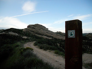
The Pacific Crest Trail at Mormon Rocks

Civilization grew closer, as I crossed railroad tracks, walked past dilapidated homes, and the hum of Interstate 15 became louder.  I crossed a creek, but chose to continue on, knowing that the water at McDonald's needed no treatment. I crossed under I-15, and arrived at the PCT trailhead at Cajon Pass. I was finished with this long day (32-miles), and celebrated with a burger, fries, and cold, delicious water!


Thursday, May 24, 2012

Pacific Crest Trail Section D: Day 2

Day 2 Winston Spring to Camp North of Vincent Gap - 25-miles

Burkhart Trail Alternate Route
After studying my maps, courtesy of Halfmile, I realized that hiking was going to involve a road walk for several miles along Highway 2. Great... The PCT is closed from Eagle's Roost to the Burkhart Trail through the lush Copper Canyon.  However, the closure is there for good reason. The nearly extinct Mountain Yellow-Legged Frog once thrived in this area, and in order to protect its breeding grounds, hikers are prohibited from traipsing through this area.

What I did not realize is that there is a better alternate route that I took on this trip. I had Half-Mile's maps from last year, which told me to take the road walk. Now there is an longer, more circuitous alternate that travels through Devil's Punchbowl County Park (which I have heard is quite scenic!) that is the official PCTA detour. Oh well...

Panoramic View From Saddle Below Mt. Williamson
From Cloudburst Summit I descended the PCT to Copper Canyon. I remember this stretch well from my 2003 thru-hike, as it traveled through dense, lush forest, and provided plenty of water for the parched hiker. I ascended the Burkhart Trail up to Buckhorn Camp, and then took a cross country route up to Highway 2. For the next 4-miles, I walked a sun-drenched highway, passing by an old, dilapidated ski resort, and the occasional off-road picnic area. There was little traffic on the road this early in the season, so the miles were not so sketchy, just hot!

Little Jimmy Spring - a critical (and great!) water source!
At Eagle's Roost, I rejoined the PCT near a large, white highway maintenance building, and climbed up a few hundred feet, and after a short mile, dropped again back to Angeles Crest Highway.  I really hate how the PCT runs in the shadow or hovers over this highway. Motorbikes and discarded trash on and around this high really detracts from any wilderness feel one might get in the San Gabriels.

The PCT then climbs steadily towards the top of Mount Williamson. Actually, the trail skirts just below the summit, but one can take a short side trail to a rewarding panoramic view.  I took a break on the saddle just below the summit, and noticed on my maps that the trail dived right back down to the highway... yep, this is one of those PCT PUDS (pointless ups and downs), established perhaps because the trail is displaced by the highway.  I enjoyed some homemade jerky, fruit leather, and GORP, removed my shoes and socks, and took in the pleasant view.

Mt. Baden Powell Summit
Summit of Mt. Baden-Powell
The descent to the highway was quick, painless, and quite pleasant.  Going down, I could see how the trail climbed straight back up the mountainside on the other side of the road. More climbing. I had a half liter of water for the next two miles, and was parched on this warm day full of ascents, and I looked forward to refilling at Little Jimmy Spring.  Luckily, the trail ducked under the cooler cover of trees about half mile south of the highway, and then started running into occasional patches of snow covering the trail.  I munched on snow.

I passed through a snow-blanketed Little Jimmy Campground, and after another .2-mile, arrived at Little Jimmy Spring.  I chugged a liter right on the spot, and filled up another two liters for the 8-mile stretch to Lamel Springs.

Ancient Limber Pine
Higher up, the snow patches gave way to snow fields, and often I lost sight of the trail.  I soon figured that it was best to just hike cross-country off the snow, especially along the ridges.  Sometimes I followed other foot prints off trail, and other times I was blazing my own path.  I asked myself, "Why did the trail builders put the PCT on the snow-prone north side of the ridge, and not on the south side?" It seemed like the trail could easily be on the other side of the ridge... oh well.

At 6:41 pm I arrived at the summit of Mount Baden-Powell, named for Lord Robert Baden-Powell, the founder and Chief Scout of the Scout Movement.  This peak is a pilgrimage for many scouts hiking the Silver Moccasin Trail, and a sturdy monument dedicated to Baden-Powell stands just slightly off the summit.

More interesting than the monument are the ancient limber pines that grow just below the summit of the peak. These stout, drought tolerant, wind-loving trees stand like arthritic, gnarled guardians, with centuries-old battle scars. Many of them have old exposed root systems, which have endured the steady erosion of the soil. They are beautiful trees, and one of them is estimated to be 1,500-years old!

Alpenglow in the San Gabriels along the Pacific Crest Trail
Alpenglow in San Gabriels
With the sun setting, I began my scramble down the snowy north face of this mountain.  Apparently snow fell on this mountain a few weeks back, and there was no trace of the PCT going down... none.  The only thing I had to go on were steps in the snow, which I followed, despite the waning daylight.  The snow was mushy, and a couple times, I postholed mid-thigh, especially early on.  Later, I found switchbacks, which I followed closely, since I was looking for the side trail to Lamel Springs.

When I gathered water at Lamel Springs, I could barely see the side path leading me back to the PCT.  Snow was still prevalent along the trail, and I did not feel like crossing the patches in the dark.  I hoped to find a flat spot soon.  About a mile south of Lamel Springs, I came to a small flat rest spot with two benches, just off the crook of a switchback.  In spite of wind gusts, I set up my tent, cooked supper, and rested my weary feet.  I had just hiked 25+ miles for the day, which included climbs up Mt. Williamson and Baden-Powell.  Rest was justified!

Monday, May 21, 2012

Pacific Crest Trail Section D: Day 1

Introduction

View North Toward Mill Creek Summit
When I thru-hiked the Pacific Crest Trail (PCT) in 2003, I blazed through sections of which I have little recollection. Since that time, I have been revisiting the PCT, and hiking sections to rekindle my love affair with this trail, relive memories of 2003, and get a better in-depth experience of a section. Recently, I hiked a 77-mile (or 75?) section of trail from Mill Creek Summit to Cajon Pass.

I had hoped to hike this section last year when I did sections F and E, but it was closed. In 2009, the Station Fire, one of largest wildfires in California history, scorched large portions of San Gabriel Mountains in the Angeles National Forest, and forced all 2010 thru-hikers to walk roads from the Wrightwood to Agua Dulce - that must have sucked.

The highlight of this section is without a doubt, the climb up Mt. Baden-Powell, whose snow-covered north slopes can pose a formidable challenge to the early season hiker - I will mention more about that later!  This section also presents the opportunity to take a side route and climb Mount San Antonio (Mt. Baldy), the highest peak in the San Gabriel Mountains.

Day 1 Mill Creek Summit to Winston Spring - 19-Miles

Mill Creek Summit is near the epicenter of the fire, and it's shaded picnic area was completely destroyed. A new new restroom facility stands naked at this exposed road crossing, surrounded by barren slopes, denuded from the fire. This was my starting point.

wildflowers emerge from station fire burn
Wildflowers Emerge From Station Fire Burn
The PCT climbs gently but steadily along slopes, which used to be filled with manzanita, chamise, and Our Lord's Candle (Mojave Yucca).  Now Poodle Dog Bush, which can cause skin irritations for many brushing against it, grows abundantly along the trail, protecting the soil from erosion.  Occasionally, the trail darts under the cover of pines, whose dark, charred remains provide little escape from the high sun.

After climbing toward the top of Pacifico Mountain, the fire damage becomes less noticeable. Sweeping views to the east reveal the expanse of the Mojave Desert, and to the north, the fire damage along the slopes of Mount Gleason.

Descending Pacifico Mountain, I returned to the chaparral that I was familiar with from my 2003 thru-hike. Near Sulphur Springs campground, I refilled my water bottles with water I had to take a chance on. Unfortunately, the part B bottle of my Aqua-Mira sprung a leak, leaving me without water purification. Yep, I'd be dipping and sipping the rest of this hike!

Sunset in San Gabriels
The trail meandered to my first crossing of the Angeles Crest Highway at Three Points. For many northbound hikers, Three Points represents the last of many crossings over this scenic highway.  From Three Points, the Pacific Crest Trail parallels the highway, which is occasionally hidden by a hillside or below an escarpment.  I found the highway to be a nuisance because of the occasional engine noise from cars and the proliferation of garbage, which seems to drift toward the edge of the trail. I wish the trail would take a different route away from the highway. Ugh.

From Three Points, the PCT joins up with the Silver Moccasin National Recreation Trail, a 53-mile long hike that is popular among boy scouts seeking their Silver Moccasin Trail badge.  I hiked about a mile beyond Three Points to a small rill, where I retrieved water, and cooked a macaroni and cheese meal.  Continuing on, I passed Camp Glenwood, a rustic looking camp, equipped with a couple pit toilets, and made camp about a mile north of Cloudburst Summit. I found a nice flat spot, and conveniently tied my food up on a single, low transmission line hovering over my campsite.  I laid down, and let the sound of a gentle flow of water through Cloudburst Canyon lull me to sleep.

Friday, May 4, 2012

Condor's PCT Adventure in 3-Minutes

One of the videos featured at Annual Day Zero Pacific Crest Trail Kickoff's Video Shorts Festival was "Condor's PCT Adventure in 3-Minutes."  I've seen SunWalker's facial transformation video, which is awesome, but Condor's video definitely takes the cake. He won the "Best Spirit of the PCT" category for this video, so check it out:


Condor (Kolby Kirk) also runs a website called thehikeguy.com, which is loaded with information about his hikes, and includes hiker outings out of the Bend, Oregon area.  Condor also has a few clips from his journals, which are amazing pieces of art work. Seriously, the time, detail, and effort he puts into his colorful, textured journals tell a multifaceted story, which cannot be captured online. I got to travel back to Oregon with him, and he showed me his journal for his upcoming Sierra Trek Hike.  I was utterly amazed at what he had already written, painted, and "stickered"into his journal before the big hike. Very cool.