Day 2 Winston Spring to Camp North of Vincent Gap - 25-miles
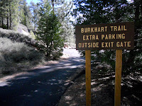 |
| Burkhart Trail Alternate Route |
After studying my
maps, courtesy of Halfmile, I realized that hiking was going to involve a road walk for several miles along Highway 2. Great... The PCT is closed from Eagle's Roost to the Burkhart Trail through the lush Copper Canyon. However, the closure is there for good reason. The nearly extinct
Mountain Yellow-Legged Frog once thrived in this area, and in order to protect its breeding grounds, hikers are prohibited from traipsing through this area.
What I did not realize is that there is a better alternate route that I took on this trip. I had Half-Mile's maps from last year, which told me to take the road walk. Now there is an longer, more circuitous alternate that travels through
Devil's Punchbowl County Park (which I have heard is quite scenic!) that is the official PCTA detour. Oh well...
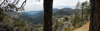 |
| Panoramic View From Saddle Below Mt. Williamson |
From Cloudburst Summit I descended the PCT to Copper Canyon. I remember this stretch well from my 2003 thru-hike, as it traveled through dense, lush forest, and provided plenty of water for the parched hiker. I ascended the Burkhart Trail up to Buckhorn Camp, and then took a cross country route up to Highway 2. For the next 4-miles, I walked a sun-drenched highway, passing by an old, dilapidated ski resort, and the occasional off-road picnic area. There was little traffic on the road this early in the season, so the miles were not so sketchy, just hot!
 |
| Little Jimmy Spring - a critical (and great!) water source! |
At Eagle's Roost, I rejoined the PCT near a large, white highway maintenance building, and climbed up a few hundred feet, and after a short mile, dropped again back to Angeles Crest Highway. I really hate how the PCT runs in the shadow or hovers over this highway. Motorbikes and discarded trash on and around this high really detracts from any wilderness feel one might get in the San Gabriels.
The PCT then climbs steadily towards the top of Mount Williamson. Actually, the trail skirts just below the summit, but one can take a short side trail to a rewarding panoramic view. I took a break on the saddle just below the summit, and noticed on my maps that the trail dived right back down to the highway... yep, this is one of those PCT PUDS (pointless ups and downs), established perhaps because the trail is displaced by the highway. I enjoyed some homemade jerky, fruit leather, and GORP, removed my shoes and socks, and took in the pleasant view.
 |
| Summit of Mt. Baden-Powell |
The descent to the highway was quick, painless, and quite pleasant. Going down, I could see how the trail climbed straight back up the mountainside on the other side of the road. More climbing. I had a half liter of water for the next two miles, and was parched on this warm day full of ascents, and I looked forward to refilling at Little Jimmy Spring. Luckily, the trail ducked under the cooler cover of trees about half mile south of the highway, and then started running into occasional patches of snow covering the trail. I munched on snow.
I passed through a snow-blanketed Little Jimmy Campground, and after another .2-mile, arrived at Little Jimmy Spring. I chugged a liter right on the spot, and filled up another two liters for the 8-mile stretch to Lamel Springs.
 |
| Ancient Limber Pine |
Higher up, the snow patches gave way to snow fields, and often I lost sight of the trail. I soon figured that it was best to just hike cross-country off the snow, especially along the ridges. Sometimes I followed other foot prints off trail, and other times I was blazing my own path. I asked myself, "Why did the trail builders put the PCT on the snow-prone north side of the ridge, and not on the south side?" It seemed like the trail could easily be on the other side of the ridge... oh well.
At 6:41 pm I arrived at the summit of Mount Baden-Powell, named for
Lord Robert Baden-Powell, the founder and Chief Scout of the Scout Movement. This peak is a pilgrimage for many scouts hiking the Silver Moccasin Trail, and a sturdy monument dedicated to Baden-Powell stands just slightly off the summit.
More interesting than the monument are the ancient limber pines that grow just below the summit of the peak. These stout, drought tolerant, wind-loving trees stand like arthritic, gnarled guardians, with centuries-old battle scars. Many of them have old exposed root systems, which have endured the steady erosion of the soil. They are beautiful trees, and one of them is estimated to be 1,500-years old!
 |
| Alpenglow in San Gabriels |
With the sun setting, I began my scramble down the snowy north face of this mountain. Apparently snow fell on this mountain a few weeks back, and there was no trace of the PCT going down... none. The only thing I had to go on were steps in the snow, which I followed, despite the waning daylight. The snow was mushy, and a couple times, I postholed mid-thigh, especially early on. Later, I found switchbacks, which I followed closely, since I was looking for the side trail to Lamel Springs.
When I gathered water at Lamel Springs, I could barely see the side path leading me back to the PCT. Snow was still prevalent along the trail, and I did not feel like crossing the patches in the dark. I hoped to find a flat spot soon. About a mile south of Lamel Springs, I came to a small flat rest spot with two benches, just off the crook of a switchback. In spite of wind gusts, I set up my tent, cooked supper, and rested my weary feet. I had just hiked 25+ miles for the day, which included climbs up Mt. Williamson and Baden-Powell. Rest was justified!


